Description
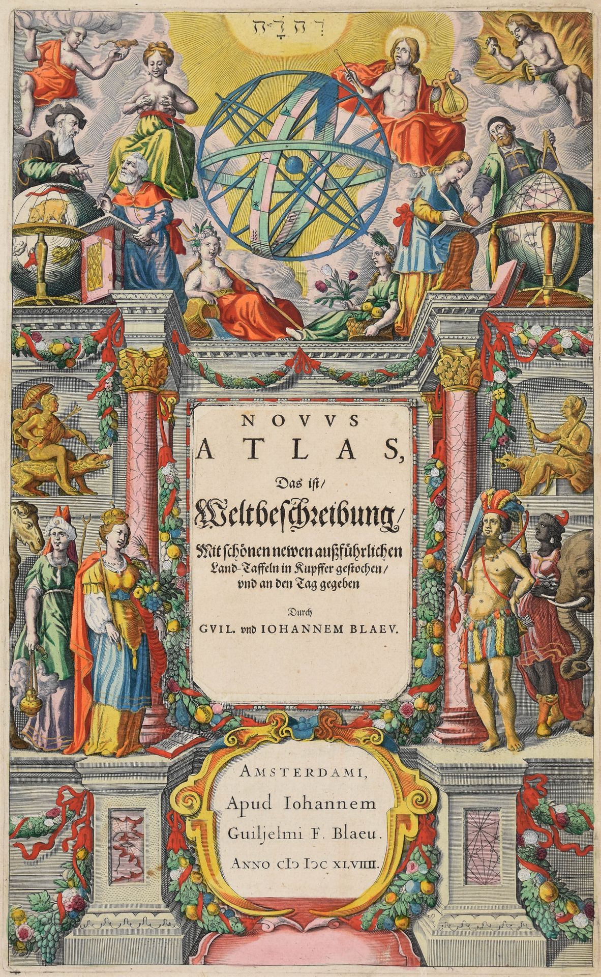
BLAEU, Joannes Novus Atlas, das ist, Weltbeschreibung, mit schönen newen aussführlichen Land-taffeln in Kupffer gestochen, und an den Tag gegeben. Amsterdam J. Blaeu 1649 Large folio: [10 incl. engr. title]-21-72 pp.; 62 (of 84) maps, lavishly hand-coloured with a nice gold and silver heightened title (22 maps missing, title with sm. tear in margin repaired, some marg. repairs and dampstains, esp. in the map of Moravia, marg. tear in the folded map of Alsace). Mod. calf, gilt decorated spine. In slipcase. First part of 1st vol., in the 2nd German edition of Blaeu's three-volume "Theatrum orbis terrarum" (1st Lat. ed.: 1640, 1st German: 1641), covering Northern and Eastern Europe, as well as Germany. Illustrated with 62 (of 84) maps. For some of these, Blaeu used maps from the stock and altered their signature in manuscript, as on n. 17/9. The following maps are missing: 1. World map, 3. Europe, 16. Magni Ducatus Lithuanuae, 17. Map of the Dniepr, 19. Prussia Nova Tabula, 20. Nova tutius Germaniae descriptio, 22. Rugia insula ac ducatus, 23. Meklenburg ducatus, 29. Ducatus Holsatiae Nova Tabula, 30. Map of the Elbe River, 31. Circulus Westphalicus, 39. Waldeck Comitatus, 41. Frankfurt am Main, 43. Hassia Landgraviatus, 48. Bohemia, 54. Map of the Danube River, 67. Sveviae Nova Tabula, 69. Map of the Rhine River, 76. Palatinatus ad Rhenum, 79. Coloniensis Archiepiscopatus, 80. Iuliacensis et Montensis ducatus, 83. Archiepiscopatus Trevirensis. Ref. van der Krogt II [2:232.1LJ].
1067
BLAEU, Joannes Novus Atlas, das ist, Weltbeschreibung, mit schönen newen aussführlichen Land-taffeln in Kupffer gestochen, und an den Tag gegeben. Amsterdam J. Blaeu 1649 Large folio: [10 incl. engr. title]-21-72 pp.; 62 (of 84) maps, lavishly hand-coloured with a nice gold and silver heightened title (22 maps missing, title with sm. tear in margin repaired, some marg. repairs and dampstains, esp. in the map of Moravia, marg. tear in the folded map of Alsace). Mod. calf, gilt decorated spine. In slipcase. First part of 1st vol., in the 2nd German edition of Blaeu's three-volume "Theatrum orbis terrarum" (1st Lat. ed.: 1640, 1st German: 1641), covering Northern and Eastern Europe, as well as Germany. Illustrated with 62 (of 84) maps. For some of these, Blaeu used maps from the stock and altered their signature in manuscript, as on n. 17/9. The following maps are missing: 1. World map, 3. Europe, 16. Magni Ducatus Lithuanuae, 17. Map of the Dniepr, 19. Prussia Nova Tabula, 20. Nova tutius Germaniae descriptio, 22. Rugia insula ac ducatus, 23. Meklenburg ducatus, 29. Ducatus Holsatiae Nova Tabula, 30. Map of the Elbe River, 31. Circulus Westphalicus, 39. Waldeck Comitatus, 41. Frankfurt am Main, 43. Hassia Landgraviatus, 48. Bohemia, 54. Map of the Danube River, 67. Sveviae Nova Tabula, 69. Map of the Rhine River, 76. Palatinatus ad Rhenum, 79. Coloniensis Archiepiscopatus, 80. Iuliacensis et Montensis ducatus, 83. Archiepiscopatus Trevirensis. Ref. van der Krogt II [2:232.1LJ].